


SatWeather app for iPhone and iPad
Developer: Andrea Tondo
First release : 06 May 2011
App size: 27.2 Mb
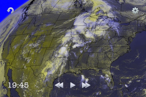
SatWeather is a new type of weather application that allows you to see REAL TIME IMAGES received from the satellite in order to understand the evolution of disturbances and the position of clouds over you.
With this tool you can have a clear and precise idea on the REAL weather conditions by analyzing the movement of clouds.
The images cover the whole area of UNITED STATES, CANADA, MEXICO and EUROPE.
Available for United States and Canada:
- a unique picture for United States, Canada and Mexico (good definition) 24/7.
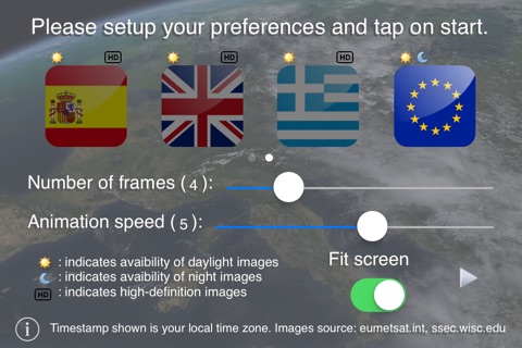
The animation shows the last 4 hours clouds movement, which can be reduced (speeding up the download time) by selecting the desired number of frames (from 1 to 8). Every 30 minutes there is a new image. (Note: the frames are available approximately 10 minutes after the image is captured by the satellite: the image of 10:15am can be downloaded on your device at around 10:25am).
Available for Europe:
- an overall picture across Europe (unfortunately with low resolution) 24/7;
- a detailed view (high definition) for the following countries: Italy, France, England, Germany, Switzerland, Austria, Spain, Greece (full list at the bottom of this description); those are available only for the daylight hours, from 4am to 7pm UTC.
The animation shows the last 16 hours clouds movement, which can be reduced (speeding up the download time) by selecting the desired number of frames (from 1 to 16). Every hour there is a new image. (Note: the frames are available approximately 25 minutes after the image is captured by the satellite: the image of 10am can be downloaded on your device at around 10:25am).
With the new update a "Fill Screen" option was introduced, giving you the ability to automatically adjust the size of the animation to fill the device screen!
The application is compatible with iPhone, iPod, iPad!
List of available countries in detail:
Albania
Austria
Belgium
Bosnia Herzegovina
Bulgaria
Croatia
France
Germany
Greece
England
Ireland
Italy
Macedonia
Montenegro
Netherlands
Poland
Portugal
Czech Republic
Romania
Serbia
Slovakia
Spain
Switzerland
Obviously an Internet connection is required to download images. It may rarely happen, for reasons not attributable to developers, that a snapshot of a particular time could not be available.